
Monday, April 30, 2012
Polar with a past Klan member. lol
Monday, April 23, 2012
Suzanne and Molly go to Jonesboro, Illinois
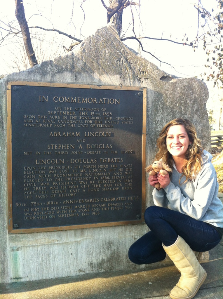

On March 5, 2012, Molly and I traveled to Jonesboro, Illinois. We stopped at the site of the 3rd Lincoln Douglas Debate. On September 15, 1858 Abraham Lincoln and Stephen Douglas came to the Jonesboro fair-grounds to fight over the a seat in the senate. There was a total of seven debates and Jonesboro was their third stop on their debate tour. Lincoln lost the debate to Douglas but gained popularity which helped him win the presidential election in 1860.
Molly and I traveled a total of 43.09 miles. This brings Molly's total miles of travel to 4,590.42!
Sunday, April 22, 2012
Molly and Katie Go to Fort De Chartres

I took Molly to Fort de Charters in Prairie du
Rocher, IL.
Fort de Chartres is the last of
three eighteenth-century forts by that name erected near the Mississippi River
by France's colonial government. From 1720 to 1763 French administration of the
Illinois Country was centered at the forts, built successively over a 40-year
period on or near the same site. The stone fort, built in the 1750s and
abandoned in 1771, has been partially reconstructed to provide a glimpse of
life in Illinois under the French regime. Fort de Chartres State Historic
Site, which also preserves the archaeological remains of the earlier wooden
forts, is managed by the Illinois Historic Preservation Agency.

The total distance that Molly and I traveled was 122 miles.
This brings our class total to 4,547.33miles.
Molly and Polar Go to WF!

Historical Museum Website-http://www.usgennet.org/usa/il/county/franklin/frankfortarea.html.
Tuesday, April 17, 2012
Polar & Alexandra Go to Marion Tower Square
 Polar and I traveled to the Marion Tower Square to visit the deceased Veterans memorial in Marion, Illinois. The stone is dedicated to all the deceased veterans of all the wars of the United States of America. It stands on east side of the square and was dedicated in 1960. The total distance traveled was 50.0 miles. That means that Polar has traveled 6,330.38 miles!
Polar & Kaitlyn Travel to Tippecanoe Battlefield

Titanic and I first traveled to my home Crete, IL (a suburb of Chicago) then we made a trip to West Layfette Indiana for the day. West Layfette just happens to be near the Tippecanoe Battlefield Memorial located in Battle Ground, Indiana. The memorial park is a National Historic Landmark. On November 11, 1811 Gen. William Henry Harrison led his troops into battle against representatives of Tecumseh's Native American confederation. Tecumseh and his brother Tenskwatawa were leaders of a confederacy of Native Americans from various tribes that opposed U.S. expansion into Native territory. As tensions and violence increased, Governor Harrison marched with an army of about 1,000 men to disperse the confederacy's headquarters at Prophetstown, near the confluence of the Tippecanoe and Wabash Rivers. Harrison camped near Prophetstown on November 6 and arranged to meet with Tenskwatawa the following day. Early the next morning, warriors from Prophetstown attacked Harrison's army. Although the outnumbered attackers took Harrison's army by surprise, Harrison and his men stood their ground for more than two hours. The Natives were ultimately repulsed when their ammunition ran low. After the battle, the Natives abandoned Prophetstown. Harrison's men burned the town and returned home. Unfortunately, Titanic and I were alone so I was not able to get a picture of us together at this historic site. The total miles traveled was 806.66, which means Polar has traveled a total of 6,280.38 miles!! WOW!
Monday, April 16, 2012
Andrea and Molly Brown Go See Boomer!!!
 Molly and I went to visit the plaque that remembers Boomer the dog in Makanda, Illinois. The total distance traveled was 20.18 miles.
The plaque on the monument reads: "In memory of Boomer the hound dog. Tradition says he dashed his life out against the iron abutment of the railroad bridge 300 feet south of this point on September 2, 1859, while running along on three legs trying to put out the flame in a hotbox on the speeding train of his beloved fireman-master." Legend was that Boomer could outrun trains, and the railroad didn't like it.
Story taken from: http://www.roadsideamerica.com/story/2988
Molly Brown goes to Burden Falls

Molly Brown came to visit my family and me on April 10, 2012. She wanted to know what there was to do in rural Southern Illinois, so we went hiking at Burden Falls. We drove to the small parking area and then hiked approximately 6 miles (3 in and 3 out). It had not rained recently, so there was only a small amount of water in the falls. Molly wanted her picture taken to remember this trip, so she and I took one in front of the Burden Falls sign. After the long hike, Molly was tired and sat on my shoulder closest to the sign.
Burden Falls is located in the Shawnee National Forest near Eddyville, IL. There was very little glacial erosion which caused the steep slopes and ledges. The waterfall is more than 100 feet high, one of the highest waterfalls in Illinois. The wilderness area was designated in 1990 under the Illinois Wilderness Act and covers over 3,600 acres. The best time to view the falls is the spring and fall, especially after a rain. Burden Falls is one of the many hiking and nature attractions in the Shawnee National Forest. Even though there was only a small waterfall, we had a great time looking at other beautiful things in the forest!!
Molly and I traveled 110.2 miles in the car and 6 miles on foot, so our round-trip was 116.2 miles. Since her trip with Tessa, Taylor, Katie, and Andrea; Molly has traveled a total of 4404.48 miles!!
Wednesday, April 11, 2012
Polar and Christy go to the Saline Creek Pioneer Village


Polar, my husband, youngest daughter, and I enjoyed our visit to the Saline Creek Pioneer Village. It is less than a mile from our house so we rode our bikes to the site. It was a beautiful day and Polar enjoyed the outdoors. The village represents a pioneer settlement of the era 1800 to around 1840. It contains a Blockhouse, a saddle bag cabin, a barn with a threashing floor (one of the few remaining in the United States), a post office, a school, a Quaker Church, a jail, and a regular cabin. The Poor House (brick house in the picture), is the effort of the culture of that era to take care of the poor. As early as 1819, the Illinois General Assembly enacted a Pauper Bill requiring County Commissioners to appoint overseers of the poor for each township. This house was built in 1877 with an addition in 1904. It is only 78.46 miles round trip from SIUC. The address is 1600 South Feazel Street Harrisburg, Illinois. Polar has traveled a total of 5473.72 miles so far! Wow Polar, you have had an amazing trip so far! Can't wait to see where else you end up!
Subscribe to:
Posts (Atom)